 |
| |
The Illustrated London News
August 15, 1857
| TEA IN INDIA. - DEODHUNGA, THE HIGHEST MOUNTAIN IN THE WORLD |
| "Not many years ago England imported from India cotton piece goods. Not so now. We have inundated the latter country with finer fabrics than the Indian can produce, beside being more durable and much cheaper, although the cotton grown in India, has two long land journeys to perform, two long ship voyages to undergo, and four customshouses to pass through, besides being manufactured, bleached, and dyed. |
| "We have also beaten the Chinese in their porcelain ware. Who will say that Worcester cannot produce as beautiful china ware as ever left China? and so shall it be with her tea. We, in India, have discovered that the tea-tree is indigenous to the Himalayah mountains from China to Ladak, a distance of nearly 2000 miles. We have discovered that we have a favourable climate for the growth of tea, a proper soil for the plant, abundance of labour; and experiments have shown that success will and must attend any attempts to rear the tea plant in the Himalayas. May not the day arrive when we may be independent of the saucy Chinaman, and, instead of sending our ships to Canton for our tea, shall send them to Calcutta for the rich and well-flavoured teas of Assam, Chachar, Darjeeling-Kumaon, and other tea-growing districts, now springing up along the broad front of our splendid mountains? |
| "The crop of the Assam Tea Company for 1854-55 was 538,094 lb. of good, wholesome, delicious black tea. The crop of 1855-56 was 638,789 lb., of which 301,244 has already been shipped to England; and the crop of 1856-57 is expected to yield 700,000 lb., and this from an infant plantation! Already do iron boats navigate the narrow streams leading to some of the factories, carrying coal for steam machinery. Houses with corrigated galvanized iron roofs are starting up, new clearnaces are being made, and new grants of land being applied for and obtained. |
| "Darjeeling, one of the many hill sanitaria in the Himalaya Mountains, which lies upon the same meridian of longitude as Calcutta, is indebted for the introduction of the tea plant to Dr. A. Campbell, the superintendent of the Sanitarium; the introduction of the plant into Darjeeling was more as a garden experiment, and in order to obtain an evergreen; the experiment was followed by several house proprietors at the place - Dr. Withcombe, Mr. James Grant, of the Civil Service, and Captain Samler, who all followed the example set by Dr. Campbell; but it was to Mr. Charles Quintin, of the Civil Service, that we are indebted for the tea plant being planted and cultivated with the intention of obtaining a marketable tea from the leaves; it was by his recommendation that Captain Samler cleared some waste ground and sowed tea-seed, which germinated. The Plants, by their healthy and vigirous growth, gave much promsie of the experiment succeeding; a company was speedily formed for the cultivation of tea and coffee, the success of which is still in futurity. Several thousand acres of forest land have been cleared, from 2500 feet elevation above the sea to 5900; sixty or seventy acres have been planted, besides six nurseries, in which a ton of seed has been sown this year. |
| "Mr. R. Fortune, the celebrated authority upon tea and its manufacture, in comparing the climate of the Himalayas with that of China, says that 'although some important differences occur, yet, upon the whole, there is great similarity.' |
| "Five tons of seed will be in the ground before May, 1857. |
| "The Government has generously distributed 1600 lb. of tea-seed to the natives of the hills round about the Sanitarium; and, as these men are all inveterate tea-drinkers, we may soon expect all the principal heads of villages will have their own tea plantantion, they having taken up the matter in great earnestness and spirit. At present the native tribes in the Himalayas drink tea that is imported from Thibet, which has to perform a land journey of several thousand miles before it reaches their doors. It is a coarse, harsh, black tea, whcih arrives in blocks or bricks of 6 lb, or 7 lb. weight, and eight inches in length and four inches deep, and is sewn up in raw kidskins, the tea appearing through the stitches at the sides. It costs two shillings a pound; whereas the tea that they will raise themselves will be drunk on the spot for ninepence to the pound. |
| "Tea, as at present drank in these mountains, when cooked, is excellent in taste, and highly refreshing to the thirsty traveller or husbandman. It is made after the following extraordinary manner: - Into a large iron cooking-pot full of boiling water, perhaps holding three gallons, a quantity of black tea that has been chopped from the end of a 'Thibet brick' is thrown, together with a little salt, butter, and parched barley meal; this mess, after having been well stirred, is served up in a metal teapot, each partaker of the tea producing his or her own wooden teacup from the bosom folds of their capacious clothes, and when the cup has been frequently filled, and as rapidly emptied, it is licked clean by the owner and replaced whence it was taken; everyone being supposed to carry a teacup about the person, as a Londoner does a pocket handketchief; ten or twelve cups full is considered no extraordinary drink for a tea-loving Bhoatia. |
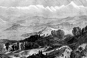
| "In the accompanying view is shown the Sanitarium at Darjeeling; which gives an excellent idea of the tea mountains, though Darjeeling itself, being at an elevation of 7400 feet, is alittle above the plantations. In the distance is the great mountain Deodhunga, sixty miles west of Darjeeling. Close to the spot whence this Sketch was taken, at an elevation of 11,500 feet, wild tea-trees were in blossom, just below the fir forest; Deodhunga, 29,002 feet in height, being on the left hand of the spectator, and Kunchinginga [Kunchenjunga], 28,176 feet in height, being on the right hand - a wonderful and glorious sight. |
| "We add some interesting details of the naming of the Deodhunga Mountain [Mt. Everest]: - |
| "On the 12th of May last two very interesting communications were read to the Royal Geographical Society of London upon Deodhunga, which mountain Colonel Waugh, in the first paper, refers to as 'higher than any other hitherto measured mountain in India, and most probably the highest in the whole world.' Colonel Waugh adds: - |
| "But here is a mountain, most probably the highest in the world, without any local name that we can discover, or whose native appellation, if it have any, will not very likely be ascertained before we are allowed to penetrate into Nepaul and to approach close to this stupendous snowy mass. |
| "The Colonel then proposes to name this noble peak of the Himalayas after his respected chief and predecessor in office (Col. George Everest) 'Mount Everest.' |
| "The second paper is a contribution from Mr. B.H. Hodgson, dated Darjeeling, Oct. 26, 1856, stating that although he agrees with Colonel Waugh as to the fitness of the name of Mount Everest, and sympathises with the sentiment which gave rise to it, he must add, in justice to the Nepaulese and to himself, who has been so long connected with them, that the mountain in question does not lack a native and ascertained name; that the name is Deodhunga, Holy Hill, or Mons Sacer. To the paper styled 'Route from Kathmandu to Darjeeling,' there is appended a 'Memorandum relative to the Seven Cosis.' In the latter occurred the following words: - ' The Bhotia Cosi has its source at the Deodhunga, a vast Himalayan peak situated sixty to seventy miles east of Gosainthan, and which Colonel Waugh conjectures may rival Kunchenginga in height.' In the rude sketch map which accompanied the paper was set down the position indicated, and that that position tallies with the position of Mount Everest is clear from the words above quoted, since 'sixty to seventy miles west of Gosainthan' answers precisely to east longitude 87 deg., Gosainthan being in 86 deg. east longitude. Thus Deodhunga and Mount Everest are both about 100 miles N.E. of Kathmandu; both are midway between Gosainthan and Kangehan; and lastly, both are by their position and by the absence of any like mass of snow in all the intervals between those peaks, identifiable with the so-called Kutighat, or the Great Gate, which annually for half the year is closed by winter upon the eastern highway of Nepaulese commerce and intercourse with Thibet and China. Round the shoulder of Deodhunga runs, as above intimated, the great eastern highway (the western being round the shoulder of Goasainthan) of the merchants and envoys of Nepaul proceeding to Lassa and Pekin; and this passage along the shoulder of the huge snowy mass of Deodhunga is denominated the Kutighat by the Hindoos and the people of the plans of India, as the passage round the huge snowy mass of Gosainthan is denominated by them the Kerung or Western Ghat. |
| "After the reading of Mr. Hodgson's paper to the meeting, the President said he was sure all who were present would be delighted if this mountain should for ever retain the name of the distinguished geographer who, following Lambton in the great trigonometrical survey of India, had been the means of carrying on that magnificent operation, whcih had been conducted to a conclusion by Colonel Waugh. A more appropriate name could not be given than that of Mount Everest; and, whatever might be its name in India, he hoped, in England at least, it would always be known by the name Everest. - Mr. Prinsep, F.R.G.S., said it was known that the Himalaya range extended many degrees in length, and that in the whole course of it there were mountains of varying heights. Some of them were the highest in the world. Those which had been really measured overhung the plains of India, and until recently it was supposed that the highest were near the source of the Ganges. Since then, however, the discovery had been made that there was a mountain 28,000 feet high; and the present discovery showed another in Thibet, within the sight of the territory of Nepaul, 29,000 feet high. |
| "When we come to measure the mountains in which the rivers of China rose we should perhaps find some of them 30,000 feet high. - Colonel Everest than paid a merited tribute to the eminent public services of Col. Waugh, and acknowledged that the compliment paid to him (Major Everest) by proposing that the mountain should bear his name. Yet, he added, there were objections to this naming which did not strike everyboy. One was that his name was not pronounceable by a native of India. The name could not be written in either Persian or Hindoo, and the natives could not pronounce it. It would be confounded with that of O'Brien, and the hill people would probably call this mountain Ob'ron. As another instance of the difficulty which the natives experienced in pronouncing English names, he might, among others, mention that the name of the 'Hon. Mr. Cavendish' was pronounced by them 'Humbel go mundee.' |
| "We have much pleasure in adding that, at the recent anniversary meeting of the Geographical Society, the Victoria or Patron-s Gold Medal was presented to Colonel Waugh - |
| "For his valuable and able extensions of the great trigonometrical survey of India, and particularly for his recent triangulation carried on through Rajputana, the Punjaub, and the Himalayan Mountains, thereby adding to our geography an accurate and intimate knowledge of a part of the globe most interesting to mankind at large, and of vital importance to Great Britain in particular. |
| "After detailing the survey, the President of the society, Sir Roderick Impey Murchinson, added: - |
| "Having determined that of all the mountains whence the affluents of the Ganges run, the loftiest summit is situated about midway along the Himalayan chain, and finding that this culminating point (N. lat. 27 deg. 56 min., E. long. 86 deg. 53 min.) was 29,002 English feet above the sea, and consequently 846 feet loftier than the famous Kunchenginga of Nepaul, Colonel Waugh has gratefully and appropriately named this, the highest known elevation in the world, Mount Everest, after his valued geographical instructor. These great results appear to come peculiarly within the scope of the society, which takes for its motto 'Ob Terras Reclusas;' for eight years ago the mere exploration of the tracts in question would have been deemed impracticable; whereas, under the direction of our medallist, a vast portion of these countries is now accurately delineated, on the basis of astronomical observations, connected by the highest appliances of modern geodetical science and art. |
| "The President then addressed Colonel Everest, and handed to him the medal, requesting him to convey it to Colonel Waugh; to which Colonel Everest appropriately replied on behalf of his esteemed successor in office." |