| 1. Harappa Archaeological Site Topography | |
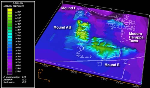
| Using data digitized from topographic maps, a digital terrain model of the entire site was constructed using EarthVision software. The major source of the data was from M.S. Vat's excavations at the site in the late 1920s. The white lines represent structures excavated, except in the modern Harappa town area where they represent current structures. A series of surfaces representing the stratigraphic surfaces of the site were also produced.
The topographical data were digitized from the original map and converted to the Harappa Archeological Research Project (HARP) coordinate system and metric units. The sitewide digital terrain model shows that the dominant topographic features are the archaeological mounds.
Slide captions 1-13 are also available in one easily printed/read document. |
|
| TECH NOTE | AUTHOR | CREDITS |
| CONTENTS | | HOME | © Harappa 1997-2010 |